
You upload a GPX file—and then DirtCompass takes over for a while. It splits up the stages, organizes the sections, and measures the terrain. Most of this happens in the background; some tasks take minutes, and once a week, it’ll try again anything that didn’t work on the first attempt.
Here’s what happens when, how you can tell, and where things are still getting stuck today.
During Upload
A GPX file is rarely just one tour. The Trans Euro Trail Switzerland includes eight tracks; the French one has twenty-nine.
That’s why we ask first, before anything is created: you’ll get a list of tracks with names and lengths, and you can check off the ones you want. Each checkmark becomes its own route—nothing is merged into a single long line. Tracks without names are called “Unnamed Track” and are assigned a number.
Files up to 25 MB are supported. That’s enough even for large collections.
The Points in the File
Many GPX files contain waypoints in addition to the tracks: gas stations, mountain huts, campsites, repair shops. Often, this is the most valuable part of the file—the Swiss TET file contains 123 of them, and the French one has 223.
We don’t just include those automatically either. On the same page, there’s a checkbox showing the number. If you check it, the points will appear under My Points. Two things to note:
- We read the type from the file; we don’t guess it based on the name. If there’s a symbol for “gas station,” it’s a gas station. “No Camping,” on the other hand, doesn’t become a campground.
- Duplicates are removed. It’s normal to import the same file twice, and two files will overlap at borders anyway. A point is considered to already exist if it has the same name and is within 100 meters. Both conditions must be met—because a file might name two gas stations separated by a valley the same thing.
By the way, you can also just use the points and skip the track entirely. Then you’ll end up directly with your list of points.
Elevations
Not every point in a file has an elevation. We fill in gaps between the measured points, and at the ends we use the nearest value—instead of inventing a trend.
Unknown remains unknown and never becomes zero. A route with no elevation data therefore shows no ascent, rather than claiming “0 meters of elevation.” And the elevation profile is omitted, rather than drawing a flat line.
Right after import: the segments
A GPX file tells you where someone rode. Not how. It doesn’t say anywhere whether a segment goes along a forest trail or a highway.
We figure that out in the background: each route is broken down into segments, and for each one, we check which riding profile can match the recorded line. Where the off-road profile can’t keep up, it’s considered road.
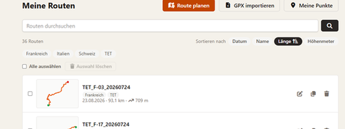
In the route list, it will say under the name:
Sections are being determined …
Expect about five seconds per route. For a file with twenty-nine stages, that’s a good two and a half minutes for the entire batch. Feel free to close the page—it’ll keep running.
This isn’t just for show. When you open and save an imported tour in the planner, it is recalculated. If everything were set to “Off-road,” the highway approach would be rerouted via dirt roads—turning 90 kilometers into 168. With the recognized sections, the route remains a route.
It’s still just a suggestion, not a rule. In the Planner, you can adjust any section, and we’ll never override your choice again.
When opening for the first time: the surface type
When you open an imported route for the first time, the line is initially a solid color. Shortly afterward, it changes color.
This is based on a measurement: we run the route through the router again and determine what kind of paths they are—paved, gravel, rough terrain. This takes a few seconds to just under a minute and a half, depending on the length. 187 kilometers: about four seconds. 665 kilometers: about eighty.
You don’t have to wait. Feel free to scroll, check out the elevation profile, and keep clicking—the colors will follow. The measurement is taken once, and the result is saved.
Even routes you plan yourself don’t need this. For those, the surface type is already determined during the calculation.
Why some things stay gray
Gray does not mean “poor trail.” Gray means: no one has recorded this information.
The terrain data comes from OpenStreetMap, and there are gaps in it. For regular paths, data is missing for 30 to 70 percent of the route; for trails, it’s as high as 86 percent. A second feature catches some of this, but by no means all of it.
That’s why, below the map, next to “Unpaved 39%,” you’ll also see “Surface unknown 8%”—as a separate figure. We don’t attribute the unknown meters to either category. That would be a guess.
And if a route remains completely colorless: that means the tracking couldn’t keep up. This happens on mixed routes with a lot of road. A single-color line is then the honest answer—better than colors for paths you’ve never ridden.
Once a Week
We update the map data that the router uses on a weekly basis. After that, a process runs automatically to catch up on what previously received no response at all—for example, because data was missing for a certain area.
So a route without surface data can correct itself within a week.
What the process doesn’t do: re-evaluate a route that already has a result. “Tried, found nothing” is also a response, and that doesn’t change on its own. If the result for a specific route seems off to you—write to us via the contact form; that’s faster than waiting.
What’s available today
- Import with stage selection, including waypoints, up to 25 MB
- Automatic detection of roads and off-road terrain
- Road surface and closures shown as colors on the map, with numbers below them
- Planning with waypoints, four route types per section (off-road, fast road, winding road, straight-line), elevation profile with gradient
- Mountain passes as a separate layer, your points as a second layer
- GPX export including all points within a one-kilometer radius
- Create a route in reverse, duplicate it, sort by keywords, delete multiple routes at once
- Download everything as a ZIP file — and delete the account along with its contents
Where it gets tricky
No sugarcoating:
A file dragged directly onto the map doesn’t yet recognize its sections. Recognition occurs during import via the normal upload page. If you drag a GPX file onto the planner, everything is initially set to “Terrain.” Save it, open it once, and then it’ll work.
Mixed routes with a lot of road sections don’t get a surface type. The route tracking can’t accurately follow a line that runs halfway along state highways. Such routes remain a single color. This is a limitation of the system, not a switch—and colorless is better than wrong.
Very long stages take time. 554 kilometers in one go takes the router about 25 seconds. The same route with a waypoint in the middle: about 10 seconds. A waypoint is the fastest thing you can do when planning.
A straight-line route leaves the elevation data for the entire trip unknown. It’s meant for places OpenStreetMap doesn’t recognize—a ford, a stretch of beach, a ferry without a route. The distance is calculated, but no one knows what the terrain is like along the way. So we don’t claim any elevation gain for the entire tour either.
If the server restarts while work is being done in the background, the process is interrupted. The route then temporarily retains its default segments or remains unmeasured. The weekly run catches up on it later.
The location search can be slow. It runs through a third-party service that allows one request per second—for all visitors combined. If multiple users access it at the same time, the system queues the requests instead of rejecting them.
When zoomed out far, you won’t see all the passes. Across the Alps, there are easily several hundred. The map will then show the highest ones and let you know that some have been omitted.
Sharing routes isn’t available yet. A link that lets you show someone a route without them needing an account—planned, but not yet implemented. Until then: Export the GPX file and send it.
What you can do
- Open a newly imported route once. This triggers the underground measurement. Nothing happens without a visit.
- Check the sections in the planner before you save an imported tour. The detection is good, but it’s just a suggestion—and any corrections you make will be saved.
- For long legs, set a waypoint in the middle. This tends to cut the processing time in half rather than double it.
- Include the points. Knowing where the next gas station is helps more than most other features when planning. When you export, all points within a one-kilometer radius are automatically included—so your navigation system gets them on its own.
- Don’t be surprised by gray. It’s the only color on the map that admits it doesn’t know something.